January 13, 2020–10:30 a.m.
NATIONAL WEATHER SERVICE
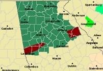
 The National Weather Service has issued a Flash Flood Watch for most of North and Central Georgia until Wednesday morning.
A frontal boundary will remain stalled across much of north and central Georgia through Wednesday morning.
Waves of moderate to locally heavy rainfall are expected today through Wednesday morning.
Soils are already saturated and additional rainfall, even lighter amounts, will only exacerbate runoff.
One to three inches of rain has already fallen over the southern and eastern Atlanta metro areas and additional rainfall amounts of one to two inches are possible through the remainder of the day.
The axis of heavier rainfall is expected to shift northward overnight and Tuesday with additional rainfall amounts of one to three inches possible.
Locally higher amounts, especially across the higher terrain of north Georgia, are also possible.
A Flash Flood Watch means that conditions may develop that lead to flash flooding.
Flash flooding is a very dangerous situation.
You should monitor later forecasts and be prepared to take action should Flash Flood Warnings be issued.